City of East Providence
Flood Protection Website
East Providence Emergency Management Agency
FEMA- NATIONAL FLOOD INSURANCE PROGRAM (NFIP):
East Providence and all other Rhode Island cities and towns participate the NFIP, which allows residents and business owners to purchase Federally-backed flood insurance. Because standard homeowners insurance doesn’t cover flooding, it’s important to have protection from the floods associated with hurricanes, tropical storms, heavy rains and other conditions. For more information on flood insurance, please visit the National Flood Insurance Program Web site at https://www.floodsmart.gov/ which includes clear and detailed information on this program.
KNOW YOUR OWN FLOOD HAZARD
The City's Emergency Management Agency is available to answer questions on the National Flood Insurance Program, and can help you to determine whether your property is in a "Special Flood Hazard Area" (SFHA, also known as the 100-Year Floodplain), which specific zone it's in, and the area's "base flood elevation". In some cases, we can supply flood depths of the "100-year flood" at your property, and we can offer advice on flood mitigation options. We can also answer questions regarding other natural hazards, flood-related or not.
Flood protection and safety information is available on links posted . The City maintains copies of FEMA’s Flood Insurance Rate Maps (hereafter, “flood maps”) which officially display the City’s Special Flood Hazard Areas. The flood maps are available for viewing in the Planning Department in Room 206 (2nd floor) of City Hall. Help with interpreting these maps is available here, and also at the Building Inspection and Engineering office in Room 204.
Official FEMA flood maps for the City can be viewed on-line using the FEMA Map Service Center. Just type your address into the box and view or download the map. You can also view a larger scale flood map for the whole city and beyond using this link, National Flood Hazard Layer, centered on City hall. You can move the map around and zoom in and out.
RIEMA has mapped out inundation zones for the whole state. Here is a link to the East Providence map.
Click here for the East Providence Hurricane Inundation Map
FEMA and the Army Corps of Engineers worked with the City to produce the East Providence Hurricane Evacuation Map (linked immediately below) based on potential for tidewater flooding resulting from a direct hit from hurricanes of Categories 1, 2, 3 or 4. This looks very similar to the "Inundation" map, but the "Evacuation" zones are a little bigger to account for areas that may become isolated due to flooding.
Click here for the East Providence Evacuation Zone Map
RHODE ISLAND FLOODPLAIN MAPPING TOOL
The Rhode Island Emergency Management Agency (RIEMA) has an interactive floodplain map on their website (linked below) that works for the whole state. The Floodplain Mapping Tool link is on the right-hand side of RIEMA's home page. Click on “View larger map” and you can zoom in to neighborhood scale and find the flood zones in your area. The white dots each represent an address...click on them to get the address of the property at that location. This is unofficial but is very accurate.
http://www.riema.ri.gov/
FEMA ELEVATION CERTIFICATES (ECs)
Elevation Certificates are used to obtain the elevation of a building to determine whether it is within the floodplain and, if so, by how much. That information figures into the price of flood insurance for a property. If an elevation certificate has been prepared for your property, you maybe able to obtain a copy from the property's developer or from the City's EMA or Engineering Offices. If an elevation certificate is not available and you need one, contact a licensed land surveyor to prepare one for you. The cost of this service varies by location; get a few quotes if possible and compare.
LOCAL FLOOD HAZARD AREAS
The primary causes of flooding for the City are prolonged heavy rainfall from large storms; torrential short-term rainfall from thunderstorms; snowmelt, often accompanied by heavy rain; and rainfall, coastal storm surges or both from tropical storms and hurricanes. The City has experienced property damage, loss of life, power outages, and interruption of transportation and communication systems from flooding. Coastal storm surges from hurricanes, while extremely infrequent, present the single most serious flood threat for the City. The 1938 Hurricane and Hurricane Carol in 1954 both caused devastating storm surges.
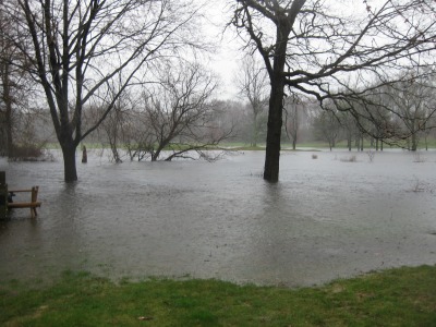
The record flooding of March 2010 illustrated what can be expected during a widespread heavy rainfall and river flooding event in the city. Among these problems are flooded basements, surface flooding in areas that drain poorly, disruption of utility service due to flooded electrical boxes, and disruption of transportation due to flooded roadways.
The following areas throughout the City have been identified as having a history of flooding that have been caused by major rainstorms, tropical storms, thunderstorms, and rapid snowmelt.
- Residential and commercial area located north of Waterman Avenue, east of Rockaway Avenue, and west of Seekonk, Massachusetts border due to the flooding of the Runnins River (commonly referred to as the State Street neighborhood)
- Commercial area at the intersection of Commercial Way and Taunton Avenue due to a combination of heavy rains, low elevation, and poor drainage.
- Residential, private country club, and open space areas located along the Ten Mile River, either side of Pawtucket Avenue, east of North Broadway and north of Centre Street, including the Agawam/Fynn Playground, due to the flooding along the Ten Mile River. This includes a portion of Pawtucket Avenue itself, a primary north-south artery in the City.
- Commercial area along Newport Avenue between Moore Street and Vista Drive due to local poor drainage of heavy rainfall.
- Corner of Ferris Avenue and Circle Street due to local poor drainage of heavy rainfall.
- Western part of Dewey Avenue near North Broadway due to local poor drainage of heavy rainfall.
- Residential area located between Grosvenor Avenue and I-195, west of North Hull Street,
and east of North Rose Street due to undersized drainage lines located under I-195.
- Portion of Pawtucket Avenue in front of Bayview Academy due to local poor drainage of
heavy rainfall.
- Veterans Memorial Parkway adjacent to Watchemoket Cove from tidal flooding.
- The intersection of South Broadway and Lee Road.
- Sabin Point Park and immediate surrounding area due to storm-driven high tides.
- Residential area along west shoreline of Bullocks Cove, and Crescent View Avenue in the area of the cove,due to storm-driven high tides.
- Residential and commercial area east of Willett Avenue, south of Forbes Street, and north of Barrington town line due to flat terrain, poor drainage, and high water tables.
FLOOD SAFETY TIPS
The Red Cross webpage and the NOAA flood safety webpage linked below offer a wealth of advice on flood safety.
Red Cross Flood Safety Checklist-Download Here.
View National Weather Service Flood Safety Website here.
SUBSTANTIAL IMPROVEMENT/SUBSTANTIAL DAMAGE REQUIREMENTS
The National Flood Insurance Program requires that all structures within a designated 100 year flood zone (in East Providence, Flood Zone VE and AE) be brought into compliance with current building standards if there is substantial damage to the structure, regardless of the cause, or if substantial improvements are added. They are defined as follows.
"Substantial damage" means damage of any origin sustained by a structure whereby the cost of restoring the structure to its before damaged condition would equal or exceed 50 percent of the market value of the structure before the damage occurred.
"Substantial improvement" means any reconstruction, rehabilitation, addition, or other proposed new development of a structure, the cost of which equals or exceeds fifty percent of the market value of the structure before the "start of construction" of the improvement. This term includes structures which have incurred "substantial damage", regardless of the actual repair work performed.
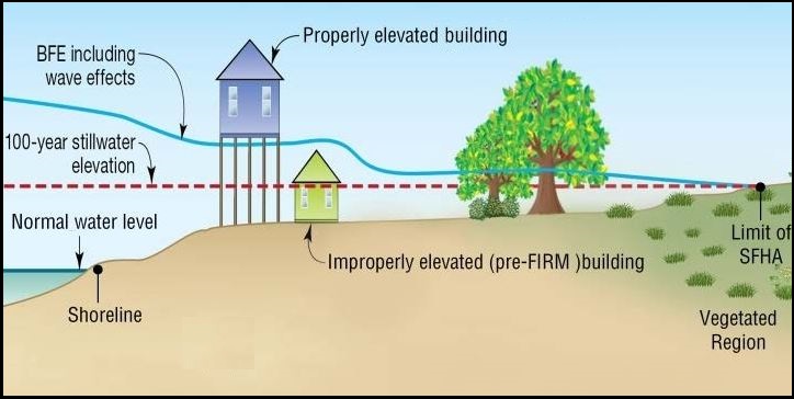
Requirements for a structure to be in compliance include: anchoring the structure against movement by floodwaters, the foundation must be resistant to flood forces and be constructed of flood resistant materials, the lowest floor must be flood-proofed (not permitted for residential structures) or elevated so the enclosed space is at least one foot above the level of the 100-year flood, and all utilities must be resistant to flood damage.
The FEMA Substantial Damage/Substantial Improvement Desk Reference can be downloaded from the FEMA webpage linked to here:
Click here for Download.
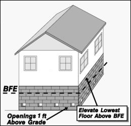
Above: Flood zone construction diagrams. V-zone new construction (left) must be open at floodplain levels, with first floor elevated one foot or more above the floodplain per the Rhode Island State Building Code, which incorporates International Building Code requirements. This V-zone open area may only be used for parking, building access, or storage. A-zone new construction (right) can have vented foundations to let floodwaters pass through.
TEN MILE RIVER REAL-TIME STREAMGAGE
The US Geological Survey maintains a river gage along the Ten Mile River at Pawtucket Avenue. The stream gage reading can be found here: Click here for River Gage.
The City is working with the USGS and the National Weather Service in determining levels of flooding relative to the readings from the stream gage. We have found that when the “Gage Height” is over 6 feet and rising, there is a likelihood of minor flooding in the State Street Neighborhood. For reference, the historic March 2010 floods featured a maximum Gage Height of about 12 feet.
Click here to download our "How to Use the Ten Mile River Streamgage" guide.
City of East Providence Floodplain Ordinance
(Adopted by City Council September 15, 2015): Chapter 19, Zoning; Section 19-306 through 19-315, Special Flood Hazard Areas.
FLOODPLAINS: NATURAL/BENEFICIAL FUNCTIONS
Flooding is a natural process that forms and maintains floodplains and coastal zones. Periodic flows of water that overtop the banks of a river and that encroach upon coastal areas are the lifeblood of river and stream corridors, marshes, beaches, and other natural areas. The seasonal variability of flow, incessant wave action, and intermittent extreme events all combine to determine both the physical structure and the biological diversity of flood prone areas. Finding the delicate balance between human needs and environmental sustainability is a difficult undertaking. Successful, sustainable flood hazard reduction solutions need to be based on the forces at work in floodplains and coastal zones and also on the resources that these flood prone areas provide.
Floodplains:
- Provide flood storage. Many floodplains temporarily store flood waters and reduce flood heights and velocities for downstream areas.
- Reduce wave damage. Some vegetated coastal floodplain areas reduce the force of waves and resulting wave and erosion damage to back lying properties and structures.
- Reduce excessive erosion. Many vegetated floodplain areas help stem erosion by reducing water velocities, maintaining stream channels and stabilizing streambank soil.
- Provide groundwater discharge. Some floodplains help maintain the base flow of streams and help to reduce ground water levels (which would otherwise flood basements)
- Produce natural vegetation. Many types of floodplains and wetlands produce natural vegetation not found in upland (dry) areas.
- Treat (remove) pollution in water body. Wetlands located in lakes, streams, estuaries, depressions, and at other locations may remove pollutants from waters.
- Provide habitat for fish and shellfish. Floodplains adjacent to rivers, lakes and the tidal waters can provide food chain support, spawning areas, rearing areas, and shelter for fish. Many estuarine wetlands provide shellfish habitat.
- Provide habitat for amphibians, reptiles, mammals, and insect species. Many floodplains and floodplain wetlands provide habitat for a broad range of mammals, reptiles, amphibians, and birds and corridors for migration or movement.
- Provide habitat for song birds and other nongame birds. A broad range of floodplains and wetlands provide habitat for nongame birds important for ecotourism.
Ways in which you can protect waterways, wetlands and floodplains:
- Do not dump pollutants into storm drains and catch basins.
- Minimize fertilizer use or use slow-release fertilizers.
- Help to keep your neighborhood litter-free
- Do not dump grass clippings, leaves, and other yard waste; utilize the City's regular weekly waste collections.
- Do not feed ducks or geese.